Remote Sensing MDPI: Journal Spotlight
This month we’re shining our Journal Spotlight onto Remote Sensing (ISSN 2072-4292), an international, peer-reviewed, Open Access journal on the science and applications of remote sensing technology.
Here, we discuss Remote Sensing’s development and achievements, charting its growth into a leading platform for high-quality research on remote sensing.
Editor-in-Chief: Dr. Prasad S. Thenkabail
Current Impact Factor: 4.1
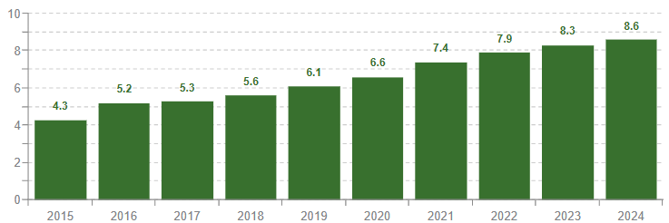
Current CiteScore: 8.6
Statistics as of November 2025.
A history of Remote Sensing
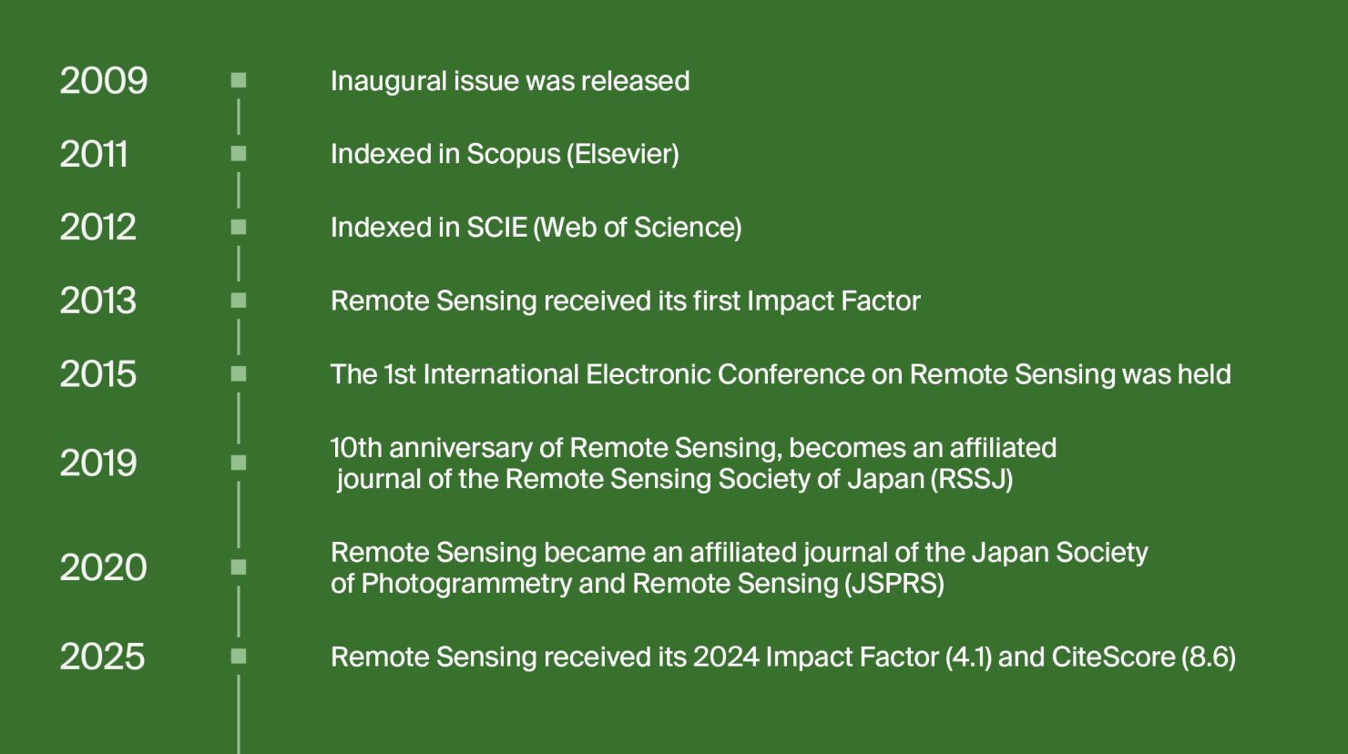
Remote Sensing was created to accommodate an increase in the number of papers being published in the ‘Remote Sensing’ section of the Sensors (ISSN 1424-8220) journal. Acknowledging the fast-growing interest in this field, the inaugural issue of Remote Sensing was released in 2009.
Remote Sensing’s earliest years were led by its first Editor-in-Chief (EiC), Prof. Dr. Wolfgang Wagner, who would be succeeded by Dr. Prasad S. Thenkabail in 2011. Under its new leadership, the journal would continue to grow its visibility, becoming indexed in both Scopus (Elsevier) and Web of Science (SCIE) by 2012.
In addition to boosting its profile, the years following this would see Remote Sensing further invest in its relationships with its academic community. The journal announced the first edition of its Best Paper award in 2013, highlighting its commitment to recognizing the outstanding work of its authors.
In 2015, the journal hosted the 1st International Electronic Conference on Remote Sensing (ECRS-1). Dr. Ioannis Gitas, the conference chair, highlighted how remote sensing is critical for addressing key issues such as climate change, biodiversity loss, and industrial pollution. Continuing its success across conferences, Remote Sensing held the International Conference on Advanced Remote Sensing 2018, in collaboration with Wuhan University, China.
In 2019, Remote Sensing also became an affiliated journal of the Remote Sensing Society of Japan (RSSJ). Similarly, in 2020, the journal also became affiliated with the Japan Society of Photogrammetry and Remote Sensing (JSPRS).
Aims and scope
Remote Sensing is the first international Open Access journal in the remote sensing field to be published in the English language.
Keen to leverage the increased visibility that Open Access provides, Dr. Wagner affirmed the journal’s mission to address pressing global environmental issues including deforestation, biodiversity loss, global carbon emissions, and more:
“My personal wish is that Remote Sensing will stimulate the exchange of scientists from around the world. This is more important than ever since climate change, continued population growth and shrinking natural resources have all become truly global problems that require, as one small part of the solution, global monitoring capabilities to better understand of how we have to act locally.”
Remote sensing is a highly interdisciplinary field which applies environmental monitoring technologies to provide insights to the physical and biological processes across our planet.
Remote Sensing’s scope covers a wide breadth of topics. These include, but are not limited to, areas such as multi-spectral and hyperspectral remote sensing, lidar and laser scanning, geometric reconstruction, and wider remote sensing applications.
A full list of the journal’s scope can be found here.
Journal metrics
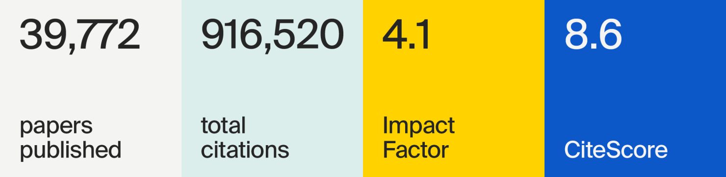
As of November 2025, Remote Sensing has published over 39,000 papers with more than 21,000 of these papers being cited 10 times or more. Impressively boasting 1532 citations, the research paper entitled “A Spatial-Temporal Attention-Based Method and a New Dataset for Remote Sensing Image Change Detection” by Hao Chen and Zhenwei Shi holds the title of the journal’s most cited article.
Often, a journal’s success can be indicated by its Impact Factor (IF), which measures the frequency with which the average article published in a journal has been cited in a yearly period. Remote Sensing’s most recent IF rating was 4.1, exhibiting great growth from its first IF of 2.1 (2012). The journal’s success across the metric can be further shown in its placement within Q1 of the Journal Citation Report ‘Geosciences, Multidisciplinary’ category.
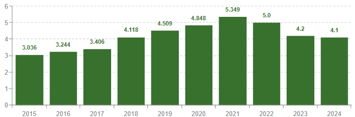
Moreover, looking towards a journal’s CiteScore can also show an estimate of its scholarly impact. At this time, Remote Sensing holds a highly respectable CiteScore of 8.6. As shown in the chart below, the journal has seen continued growth across this measurement, with its CiteScore improving every year for the past decade. To get a sense of how this correlates with other journals, Remote Sensing also sits within Q1 of the CiteScore ‘General Earth and Planetary Sciences’ category.
Remote Sensing is indexed within a vast selection of databases and archives; these include Scopus (Elsevier), SCIE (Web of Science), DOAJ, OpenAIRE, and more. Find a comprehensive list of associated indexing services here.
As of November 2025, the journal has received 3,660 mentions across news and blog outputs, and over 72,000 mentions across social media platforms. Research published in the journal is also cited across 2,795 policy documents, patents and guidelines. Amongst these references, mentions in EU policy documents discussing climate change adaptations and global flood monitoring highlight the great impact and relevance of research published in Remote Sensing.
The Remote Sensing community
Remote Sensing engages with its scholars through MDPI’s Awards program, society partnerships, and by hosting conferences.
Awards
Remote Sensing offers a range of awards to recognize the indispensable role of its reviewers and Academic Editors, and to also raise the profile of early career researchers.
The nomination deadline for both its Young Investigator Award and Travel Award closes on 31 December 2025. The winners of the Outstanding Reviewer Award were also recently announced, and the winner of its 2025 Editor of Distinction Award is to be announced on 30 April 2026.
Affiliations
Remote Sensing is currently affiliated with two societies: Japan Society of Photogrammetry and Remote Sensing (JSPRS) and Remote Sensing Society of Japan (RSSJ).
The Japan Society of Photogrammetry and Remote Sensing was founded in 1962 and is focused on advancing photogrammetry and remote sensing, as well as its applications. JSPRS is also the only society in Japan focusing primarily on photogrammetry, positioning it as a leading society in remote sensing and spatial information science.
The Remote Sensing Society of Japan (RSSJ) was later established in 1981 with the aim of collaborating on the development and dissemination of remote sensing research.
Members of these societies, or any of MDPI’s affiliated societies, enjoy a range of benefits that accompany publishing with MDPI. If you are a member of JSPRS or RSSJ, contact your society representative to learn more about the benefits of publishing with MDPI, including discounts on article processing charges.
Conferences and webinars
For journals such as Remote Sensing, conferences present a valuable opportunity for academics to connect with their wider scientific community.
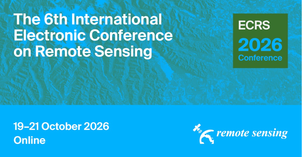
The journal will host The 6th International Electronic Conference on Remote Sensing. The event will explore topics of interest such as AI in Remote Sensing, Remote Sensing in Tropical Areas and Remote Sensing for Cultural Heritage Protection. Find a full list of topics set to be discussed here.
The event will be held online from 19 to 21 October 2026.
Testimonials
“My experience of publishing with MDPI Publishing is very positive. The homepage for the entire process is very clearly structured and easy to navigate. At least 3 reviewers are found for each paper. The reviews help enormously in improving the paper. The time schedule of only 10 days is a bit tight to be able to process the comments well. However, time extensions are available upon request. I am very satisfied with the whole process.” – Professor Dr. Angela Lausch, Helmholtz Centre for Environmental Research, author.
“MDPI journals, particularly the one I have published in, Remote Sensing, exhibit an exceptionally swift article processing speed. The editorial team is highly responsible, and the peer review feedback provided is insightful and pertinent. MDPI is undoubtedly a publisher worth considering for submitting manuscripts.” – Wenjin Sun, Nanjing University of Information Science and Technology, author.
Submitting a manuscript
Manuscripts for Remote Sensing should be submitted online at susy.mdpi.com. Prior to submitting, we recommend that authors explore the useful resources on our author guidelines webpage.
The submitting author, who is generally the corresponding author, is responsible for the manuscript during the submission and peer review process.
To submit your manuscript, register and login to the submission website. Once you have registered, click here to go to the submission form. All co-authors can see the manuscript details in the submission system if they register and login using the e-mail address provided during manuscript submission.
Stay up to date with Remote Sensing on social media: