Remote Sensing for Geohazard Monitoring and Management
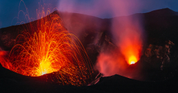
On 15th January 2022, an unanticipated eruption on a small uninhabited island in the Tongan archipelago led to natural disasters around the globe, with tsunamis emitted across the Pacific Ocean. The tsunamis, as well as the spread of a large ash cloud, were monitored from above, using satellites. Using satellites for geohazard monitoring is a common technique, as the unique viewpoint from above provides a clearer image of what is happening. There are many benefits. For example, researchers are able to accurately measure the size of the ash plume, as well as its spread pattern.
Geohazard monitoring
Weather satellites Hmawari-8, GOES-18, and GK2A were all used to work out the position and altitude of the volcanic plume from Tonga’s Hunga-Tonga Hunga-Ha’apai volcano, with the highest point of the plume reaching 55km. This is over halfway to the Kármán line (100km), which is often referred to as the boundary between the atmosphere and outer space, the highest plume in recorded history..
At MDPI, we know that scientific advancements in monitoring natural disasters are paramount. To showcase recent advancements in geohazard monitoring and disaster management, we have set up a new section in Remote Sensing: ‘Earth Observation for Emergency Management’, managed by the Section Editor in Chief, Prof. Dr. Fumio Yamazaki, of Chiba University, Japan. We spoke to Prof. Dr. Yamazaki about his new role and the importance of the new section.
Why was the section ‘Earth Observation for Emergency Management’ set up, and what appealed to you to become its Section Editor-in-Chief?
Prof. Dr. Fumio Yamazaki: I was requested to be the Section Editor-in-Chief after the section was established. So, I can only guess the reason [behind this is] that Emergency Management (or Disaster Management) is one of the most promising fields of remote sensing research and its implementation. I have been working on this field in the last two decades and I would like to provide opportunities to [the] younger generation to publish their results [in] this prestigious journal.
What recent advancements in remote sensing excite you the most?
FY: Remote sensing is one of the most promising interdisciplinary research fields in science and engineering. [In particular,] the development and deployment of advanced sensors, such as synthetic aperture radar (SAR) and light detection and ranging (LIDAR), enable us to get information on the Earth’s surface, atmosphere, ocean, and human settlements without geographical or time constraints. The development of new sensors and platforms will help us to acquire spatial data, aiming to make the Earth and our society more sustainable.
What techniques could be used to track natural disasters, such as the Tonga volcanic eruption last week, and what is the importance of tracking their progress?
FY: The Tonga volcanic eruption on January 15 [made us recognize] that our knowledge on the activities of the Earth is still limited. The interaction of the air and sea waves generated [stronger] tsunamis than the normal tsunamis [in] remote places, like Japan. Data from various sensors, including those onboard satellites, must be employed to clarify the phenomenon and to [provide] lessons for [the] future early warning [of] natural hazards.
How important are satellites to the tracking of natural disasters, and how can the information they provide help to manage the post-disaster phase?
FY: When a natural disaster occurs, it is very difficult to get information on the heavily affected area because telecommunications and road networks are disrupted. On the contrary, satellites can monitor the affected area without access, using various sensors. The information from satellites will be used [to teach us] how to provide efficient support to the affected areas. International data share activities on disaster response, such as International Charter Space and Major Disasters, and Sentinel Asia, are quite important for international aid activities in the post-disaster phase.
What impact does open access publishing have on the development of these techniques and the sharing of knowledge within the field of remote sensing and geohazard control?
FY: Open access is good for almost everybody, even though [the] article processing charge is rather high. If you do not belong to large research institutes or universities, it is not so easy to access electronic journals in [a] timely manner. High-resolution figures in full color are necessary for the articles in the fields of remote sensing and geohazard control. I believe that open access publishing is becoming more and more important and popular.
Further research on geohazard monitoring and management
The ”Earth Observation for Emergency Management” section currently has six Special Issues accepting submissions, on a variety of topics, such as The Application of Unmanned Aerial Systems in Search and Rescue Activites, and Advances in Earth Observation to Improve Flood Disaster Monitoring and Management. With open access enabling the collaboration and sharing of cutting-edge research in the field, we cannot wait to see how this exciting new section blossoms in the coming years.
MDPI has over 400 journals, so you’re bound to find a home for your research. See our full list of journals if you are interested in submitting.